HALO wind lidar
| PI | Mika Komppula |
| Operator: | Eleni Giannakaki |
| Participant | Finnish Meteorological Institute |
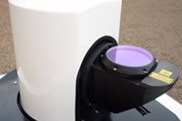
A HALO wind lidar will be used to estimate the turbulence within the planetary boundary layer in order to identify strong convection cases, capable of dispersing particles at high altitudes. The HALO instrument is provided by the Finish Meteorological Institute (FMI) and will be located next to the PollyXT-NOA lidar. The two instruments will be used to characterize the Atmospheric Boundary Layer turbulent motions in terms of updraft and downdraft properties.
The Doppler lidar, with an operational wavelength at 1.5μm, has a vertical resolution of 30m and measures the attenuated aerosol backscatter, doppler velocity and dissipation rate. Every 10min the lidar performs a conical scanning and measures the three wind components, providing information for the wind speed and wind direction. Distribution of the wind speed at a certain distance away from the lidar can be retrieved in the vertical and horizontal direction while the lidar operates under the scanning mode.
Products:
Three wind components, wind speed, wind direction with associated uncertainties.
Turbulence: attenuated backscatter at 1.5μm, doppler velocity and dissipation rate.
Instrument activity
Recent measurements
No measurements found.
The campaign is organized and funded through the ACTRIS, the European Research Infrastructure for the observation of Aerosol, Clouds, and Trace gases.