Unmanned Aerial Vehicle (UAV) coupled with a microAeth AE51
| PI | Nikos Mihalopoulos |
| Operators: | Dimitris Brilakis (UAV), Eleni Liakakou (microAeth) |
| Participants | National Observatory of Athens |
| The Cyprus Institute |
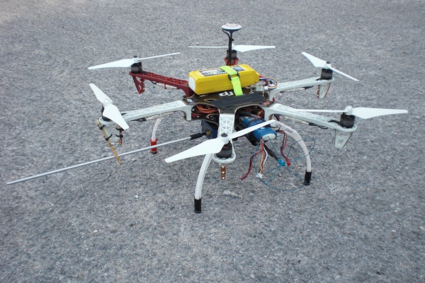
For vertical profile measurements of Black Carbon in the atmosphere the microAeth model AE51 was integrated onto a 6-rotor Unmanned Aerial Vehicle (UAV Hexacopter) with a diagonal wheelbase of 550mm and an All Up Weight (AUW) of approx. 2.5 kg. The UAV is GPS flight enabled and equipped with multiple redundancies and fail-safe RTH (Return To Home) functions. It delivered a hovering accuracy of ± 0.5m in the Vertical and ± 1m in the Horizontal axis and maximum Ascent and Descent speeds of 6m/sec and 4m/sec respectively. Flight autonomy was about 14 minutes (in full throttle) and the maximum flight altitude was set to approximately 1.000m AMSL (Above Mean Sea Level). All flights where officially authorized by the Hellenic Civil Aviation Authority (HCAA) and other relevant authorities, and where conducted in compliance to the Flight Rules of Aeromodels.
Instrument activity
Recent measurements
No measurements found.
The campaign is organized and funded through the ACTRIS, the European Research Infrastructure for the observation of Aerosol, Clouds, and Trace gases.